


Storm to end my mid morning.
School Forecast for:
Monday February 10, 2020
Last Updated: 6:05AM Monday February 10, 2020
Delay No School Early Dismissal
40%
(Medium)
10%
(Low) 0%
(Nope)
6AM Monday
Simply put, snow over night ended up being much heavier than anticipated. The liquid equivalent, which is how much water the snow is when it melts was expected to be about 0.1, however, its already at 0.2 to 0.36 across the region. As a result we've seen 1 to 3 inches of snow in most areas.
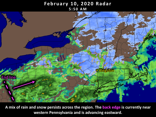
The temperature part of the forecast is on track, and air temperatures are currently 32 to 33, and rain is now being reported in Poughkeepsie. A continued transition to rain is expected before the storm tapers off around mid morning.
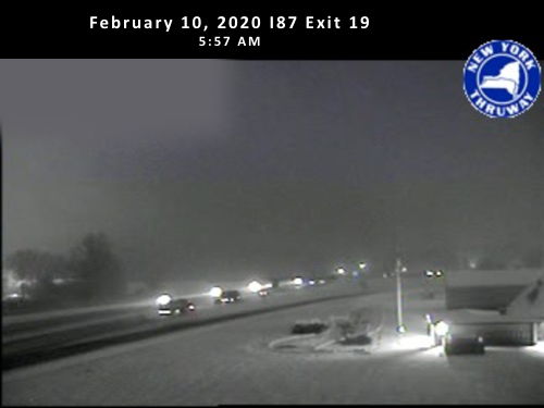
Caption: snow was plowable at the Exit 19 Police barracks.
As a rule, I do not make formal changes to the probabilities the morning of, however, given the plowable snow that has already fallen, last night's 10% of a closing has certainly increased overnight. Temperatures are already starting to edge above freezing and plowed roads will slowly improve as the storm winds down, however, given the amount of snow that has already fallen, it would not be a surprise if there was an upgrade to a closing.
9PM Sunday
A weak disturbance will move through the region tonight producing a period of light snow. Light snow is expected between 12AM and 4AM with temperatures near 30 degrees. Between about 4AM and 7AM, temperatures should start to edge above freezing, so rain or very wet snow will be likely during this time. The storm should taper off as rain between 8AM and 10AM as temperatures reach the mid 30s. Light snow accumulations of around half an inch are possible.
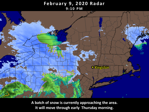
There is the potential for school impacts tomorrow. Temperatures today only got up to about 30 degrees, and are currently around 28/29. This should allow any snow accumulations to initially stick to roadways, and there is the potential for a light coating of snow in the early morning. If there are road accumulations, most roads should be totally clear by mid-morning. Based on this, whether or not Kingston has a delay tomorrow depends on how heavily the snow falls. If there's only a light dusting then classes are not likely to be impacted. If we can get closer to that half inch mark, then a delay would be more likely than not.
Delays are more likely out toward the Catskills and less likely toward Poughkeepsie. Our next shot at snow will be Wednesday night into Thursday - school impacts will again be possible for Thursday.
Extended Outlook Probabilities
Updated: 6:30AM Monday February 10, 2020
Valid through Sunday February 16, 2020
Tuesday Wednesday Thursday Friday Saturday Sunday
Delay Very Low Very Low
Medium Very Low
Very Low Very Low
Closing
Very Low Very Low
Low Very Low
Very Low Very Low
Dismissal
Very Low Very Low
None Very Low
Very Low Very Low
Snow/ice Very Low
Very Low
High Very Low
Very Low
Low
Rain Medium Very Low
Medium
Very Low
Very Low
Low
< 32°F
Medium High
High
Very High Very High High
Windy
Very Low Very Low Low
Medium Very Low Very Low
Delay, Closing, and Dismissal refer to potential school impacts. All other categories are weather conditions. Impact probabilities offer a general sense of upcoming conditions, but are not specific forecasts.
KingstonSnows ♦ Kingston, NY
258688 Visiting Snowflakes
Since January 2009
Archive of Updates
Find more about Weather in Kingston, NY


