


Impactful snow increasingly likely
School Forecast through:
Friday November 29th
Last Updated: 7:45PM Thursday November 28, 2019
Delay No School Early Dismissal
NOPE YES! NOPE
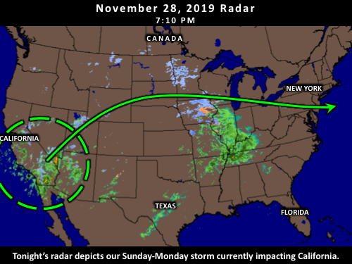
Update 7:30PM Thursday
A notable storm remains on track to impact us Sunday into Monday. This storm is has the potential to bring a long-duration snowfall beginning mid-day Sunday and continuing into Monday. Snow accumulations are likely to impact travel Sunday afternoon, possibly through Monday evening. Over the past 24 hours there have been a few new developments with this storm.
Sunday is still expected to begin below freezing with temperatures in the mid-20s. Because of this, the storm will start out as all snow. This part of the forecast has been consistent for several days now. Previous updates had mentioned that there was uncertainty in how well the cold air would remain locked in place Sunday night as the storm progressed through the region. If the storm erodes cold air more, then there will be more mixed precipitation and less snow accumulation. Over the past 24 hours, there has been a notable trend toward the cold air remaining better locked in place. This would favor colder temperatures, and greater accumulation potential Sunday night. At least some erosion of the cold air is still expected, which could result in sleet Sunday night, but at this time, a change to pure rain is less likely than yesterday. That is the first new development. We are still three days out from this part of the forecast, so there is still time for shifts. As a result the exact amounts of snow vs mixed precipitation still remain a moderate source of uncertainty, but less so than yesterday. Moderate snow accumulations are possible through Sunday night.
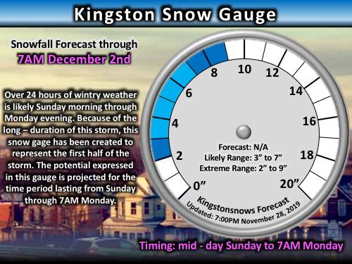
Caption: Snow gauge through 7AM Monday
The second new development centers on yesterday's uncertainty regarding how long the storm lasts on Monday. Yesterday, it was mentioned that the storm had the potential to reorganize along the coast Monday morning. In this scenario, the storm would do two things. First, it would result in a longer period of precipitation, possibly extending throughout the day on Monday. The second is that it would draw in colder air, or at least keep temperatures from rising, which would increase the potential for a change back to pure snow. Over the past 24 hours, there has been a notable trend that favors this scenario. Because of this, the potential for snow to continue through Monday evening has increased compared to yesterday. Moderate uncertainty still remains in this part of the forecast because how close the storm reorganizes to the coast still matters - the position of the new storm center will determine where the heaviest precipitation falls on Monday.
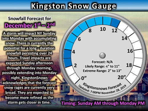
Caption: Snow gauge for the ENTIRE storm through Monday night.
Overall, accumulating snow is likely Sunday afternoon into Sunday evening. Sunday night, a change to or mix with sleet is possible. Still can't 100% rule out a period of rain, but at this point it is not very likely. In the most extreme low-end scenario, snow changes to rain late Monday significantly limiting accumulation. In the most extreme high-end scenario, snow does not mix with any sleet or rain Sunday night resulting in steady accumulation. Monday morning the storm looks increasingly likely to reorganize along the coast. This suggests that any mixed precipitation is more likely than not to change back to snow Monday morning. Snow will be possible through Monday evening, however, this remains the most uncertain part of the forecast at this time.
Next Update:
Friday evening
--------
Update 6:30PM Wednesday
Updates for the next few days will focus on the storm that is slated to impact us Sunday into Monday. This storm is currently bringing high winds and severe weather conditions to the West Coast. Over the past 24 hours there hasn't been any significant changes. The most important aspects of the past 24 hours have been that 1) all sources continue to depict this storm impacting our region, and 2) all sources continue to depict at least some snow accumulation.
Click image for larger and clearer version
At this time, it remains likely that the storm will impact us Sunday into Monday. Cold air will already be in place as the storm approaches. Warmer, moist air associated with the storm will collide with this cold air, which should allow the storm to begin as pure snow during the daylight hours on Sunday. The greatest source of uncertainty at this time remains how well the cold air remains in place. As mentioned yesterday, if the storm moves too close to us, the warmer moister air will erode the cold air which could result in a changeover to a mix or even rain. At this time, the best timing for any mixed precipitation would be late Sunday into Monday. The extent of any mixing will largely determine how much accumulation we see. Over the past 24 hours, there has been a slight trend toward favoring more mixing after the initial period of snow. A second source of uncertainty at this time is how long the storm lingers. There is some evidence to suggest that the storm may linger through most of Monday as the storm reorganizes off the coast while other computer models have it ending sooner. At this time, the best estimate is for the main precipitation to end early Monday with the possibility of additional precipitation during the day on Monday. Overall, confidence is very high in the storm impacting us, high that we'll see at least some snow accumulation, and Moderately-low that the storm will continue into Monday. I don't expect confidence for Monday's weather to increase much until Friday's update.
Next Update:
Thursday evening
--------
6PM Tuesday
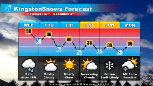
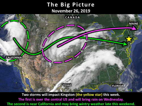
Temperatures across the mid-Hudson Valley made it up to a balmy 60 degrees today. This was the warmest that it's been since November 1st when temperatures reached 70. Unfortunately, the rest of the week will feature dropping temperatures and a more active weather pattern. Two storms will impact Ulster County before we closeout the weekend.
Click image for larger and clearer version
The first storm of the week will impact us tomorrow. Rain is likely to overspread the region Wednesday afternoon and continue through the evening. Temperatures for this storm are likely to approach 50 degrees, so it will feel notably cooler than today, especially with the lack of sunshine.The storm departs on Thursday, but should leave behind overcast skies with periodic breaks of sun. Winds also pick up Thursday behind the storm with gusts of 15 to 25 mph possible Thursday afternoon. Winds this strong will be noticeably breezy, but should not result in widespread local impacts. The biggest weather impact on Thursday could be the grounding of the balloons at the Thanksgiving Day Parade in NYC. The balloons get taken down when sustained winds reach 23 mph or gusts reach 34 mph. The National Weather Service is currently forecasting sustained winds up to 26 mph with gusts up to 39 mph in NYC. By Friday the winds will calm down and the skies should be mostly clear with temperatures only making it to around 40. Saturday remains dry, with temperatures again struggling to reach 40 degrees.
Click image for larger and clearer version
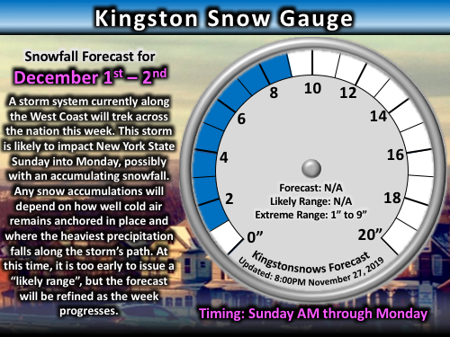
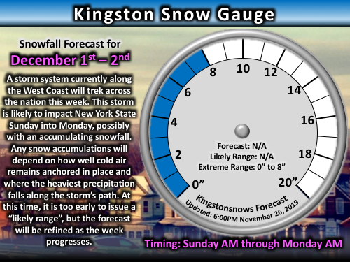
The second half of the weekend could get interesting. Clouds increase Saturday evening ahead of our second storm. This second storm is likely to bring precipitation to our region Sunday into Monday. At this time, it appears that the storm should pass far enough south to allow cold air to remain locked in place over Ulster County. This means that, at this time, a primarily snow/ice event is likely. The best estimate for timing is currently Sunday morning through Sunday night. Being five days out, it is too early to specify how much snow we are likely to see, but moderate snow accumulations are possible. The more the initial cold air remains anchored in place, the more accumulation potential there will be. If the storm moves further north, it will erode the cold air more, resulting in more mixed precipitation. At this time, confidence is moderately-high that the storm will impact us. Confidence is moderate that there will be snow impacts on Sunday.
Click image for larger and clearer version
If you're part of the Kingston City School District enjoy having the rest of the holiday week off. I plan to have daily evening updates through Friday. HAPPY THANKSGIVING!
-Ethan
Impact Probabilities
Updated: 4:15 Tuesday November 26th
Valid through Monday December 2nd
Wednesday Thursday Friday Saturday Sunday Monday
Delay Nope
Nope
Nope
Nope Nope
Medium
Closing
Closed
Closed
Closed
Closed
Closed
Low
Dismissal
Nope
Nope
Nope
Nope
Nope
Very Low
Snow/ice Very Low
Very Low Very Low
Very Low High
Low
Rain High
Very Low
Very Low
Very Low Low
Low
< 32°F
Very Low
Low
Medium
High
High
High
High Wind
Very Low
Medium
Low
Very Low Very Low Medium
Delay, Closing, and Dismissal refer to potential school impacts. All other categories are weather conditions. Impact probabilities offer a general sense of upcoming conditions, but are not specific forecasts.
KingstonSnows ♦ Kingston, NY
218566 Visiting Snowflakes
Since January 2009
Archive of Updates


